Cargando...
Recursos educativos
-
Nivel educativo
-
Competencias
-
Tipología
-
Idioma
-
Tipo de medio
-
Tipo de actividad
-
Destinatarios
-
Tipo de audiencia
-
Creador
Lo más buscado
- Ríos de Chile
- Guía didáctica
- música niños
- Lagos de Chile
- Letras Z
- Variación lingüística
- actividades lengua básica
- Repaso y material didáctico adicional
- Los planetas
- Actividades educativas para niños primer nivel
- Plantillas de letras para niños
- Mapahumano de pueblos etnias y culturas
- Actividades de lógica quinto
- problemas de básica
- Experimentos naturales
-

9. Evaluation - The representation of the Earth: maps
EduBook Organización
- 1 lo usan
- 2256 visitas
How can we use a map to calculate the real distance between two places?
-

Unit 2: The representation of the Earth: maps
EduBook Organización
- 2396 visitas
Cartography (n): the process of making maps. conventional signs (n): symbols or colours used to represent the different elements on maps. coordinates (n): geographical coordinates are a system used to…
-

End-of-unit evaluation - The representation of the Earth: maps
EduBook Organización
- 2384 visitas
In the past, cartography (or map making) was a very slow process. It involved observation and complex calculations and drawings. Modern maps are made using aerial photos and images from satellites…
-

End-of-unit activities - The representation of the Earth: maps
EduBook Organización
- 2338 visitas
In the past, cartography (or map making) was a very slow process. It involved observation and complex calculations and drawings. Modern maps are made using aerial photos and images from satellites…
-
5. Self-evaluation - The representation of the Earth: maps
EduBook Organización
- 2262 visitas
Complete this text on the representation of the Earth: To study an area of the Earth's surface we use , which is the way have represented our planet for many years. At first, this difficult job was…
-
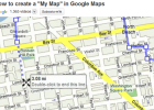
Video: How to create a 'My Map' in Google Maps
Tiching explorer Organización
- 1 lo usan
- 3492 visitas
The resource consists of a tutorial on how to create personalized, annotated, customized maps using Google Maps.
-
10. Self-evaluation - The representation of the Earth: maps
EduBook Organización
- 1968 visitas
Choose the correct answer for these questions: What do we need to know to precisely locate a point on the Earth? What exactly is map scale? What would be the best type of map to locate the most…
-
4. Self-evaluation - The representation of the Earth: maps
EduBook Organización
- 1832 visitas
Choose whether the following are large or small map scales: 1 : 10.000 1 : 10.000.000 1 : 50.000 1 : 500.000 1 : 1.000.000
-
7. Self-evaluation - The representation of the Earth: maps
EduBook Organización
- 1811 visitas
Decide whether the calculations of these distances on a map with a scale of 1:4.000.000 are correct or incorrect: Tarragona-Zaragoza: 4.9 cm on the map represent 196 km. Logroño-Granada: 15.5 cm on the…
-
8. Evaluation - The representation of the Earth: maps
EduBook Organización
- 1592 visitas
What typical conventional signs are to be found on maps?


Te estamos redirigiendo a la ficha del libro...
